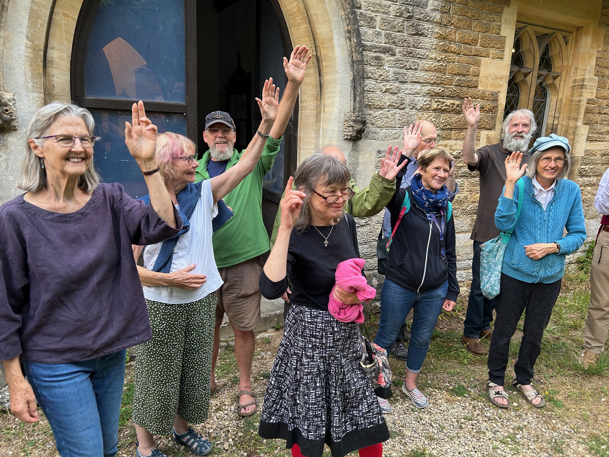
Wednesday 19 November – Annual Slideshow
The usual full house on a chilly November evening for this popular topic, which included slides from the Mike Mills collection and the SNJ archives as well as a few other sources.
Roger Carnt kicked off with “Mainly Hillside”, including these two:
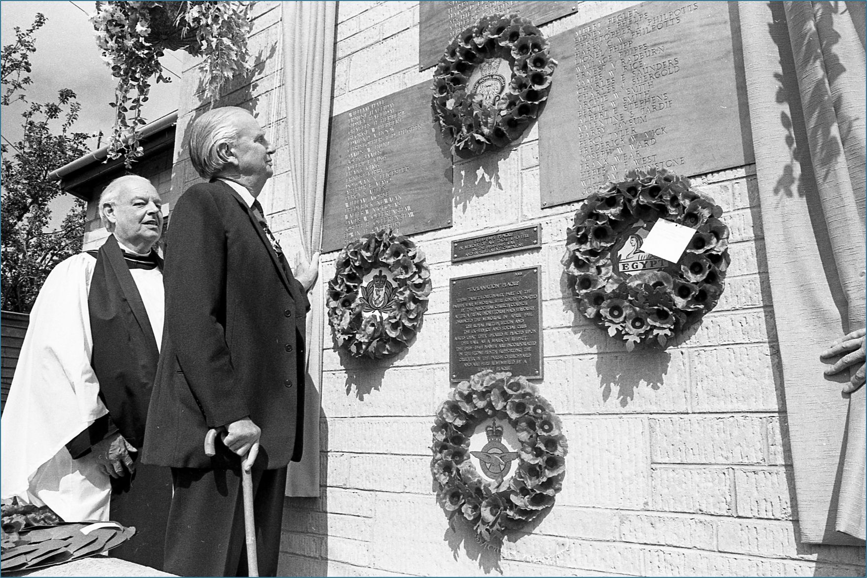
The left hand one shows the unveiling of the brass plaques from the war memorial on the old British Legion building (now Puddleducks) after they were replaced with new ones in 1981. The gentleman with the walking stick was identified by the audience on the night as Vice Admiral Janvrin.
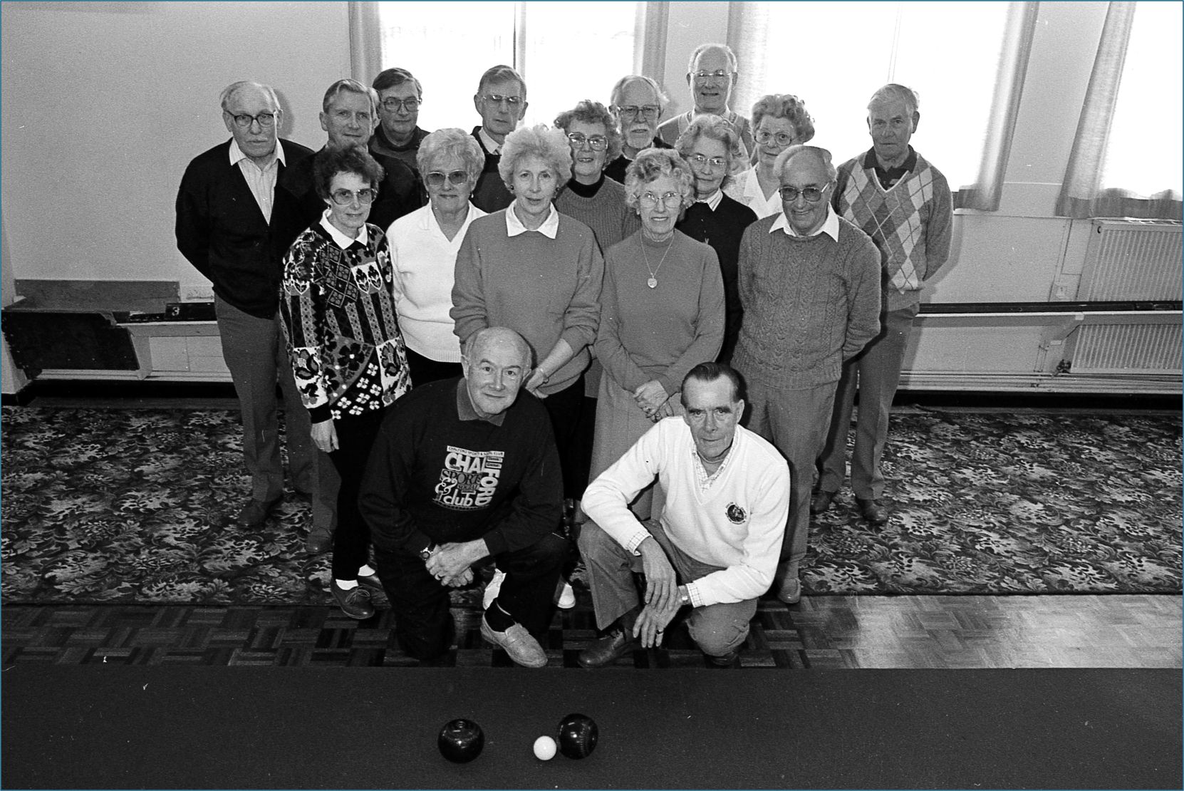
The right hand one shows the Bowls Section at Chalford Sports and Social Club and most of the people in the photo have now been identified, after the photo was posted on our Facebook Group.
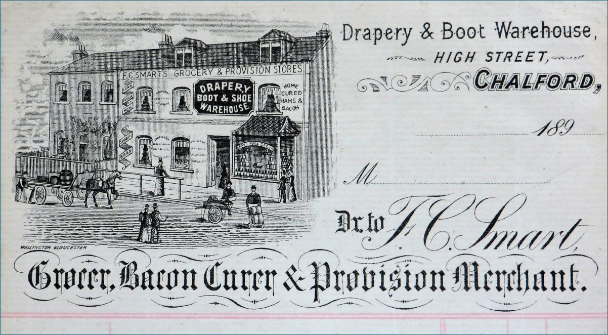
Camilla Boon then showed a selection entitled “Mainly Valley“, including these two of Smarts Shop in Chalford High St.

Heather Collins continued with “Mainly Canalside“, including these two:
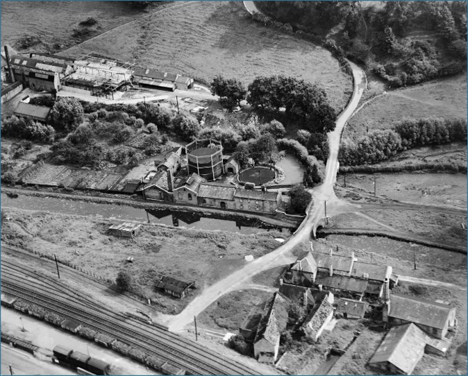
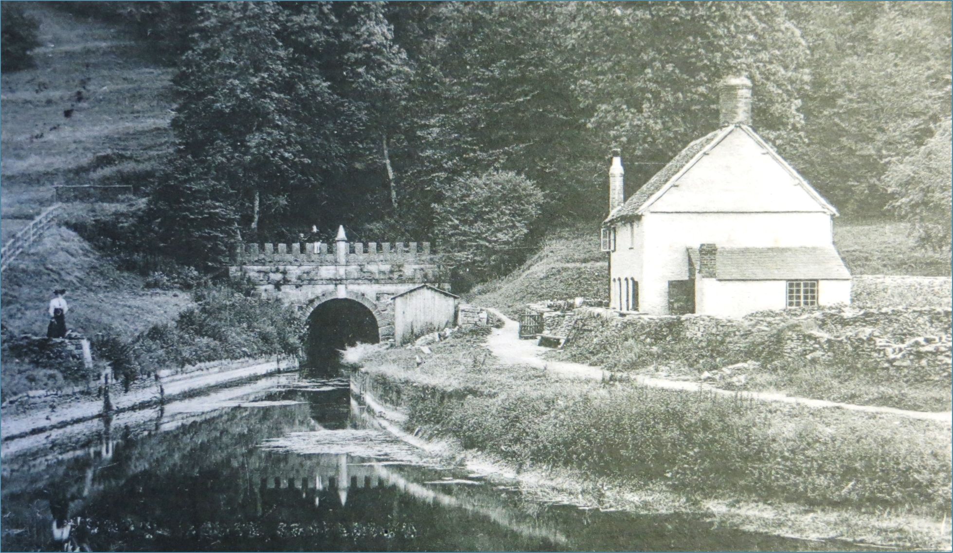
The left hand one shows the old Brimscombe Gas Works and the surrounding mills (Wimberley (Critchleys), and Bourne Saw Mills, as correctly identified by Dawn Clarke on the night!). The right hand one shows Sapperton Tunnel entrance and the Lengthman’s House (now long gone) in about 1910.
Pete Drover concluded with “Then and now“, including the stories of risking life and limb to get the “Now” shots, which are often very difficult to replicate today due to trees, busy roads and private land!
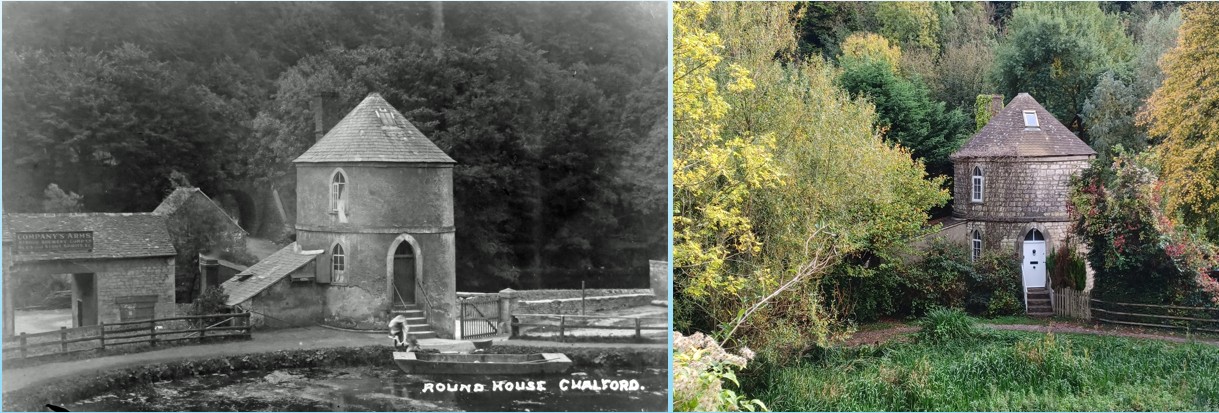
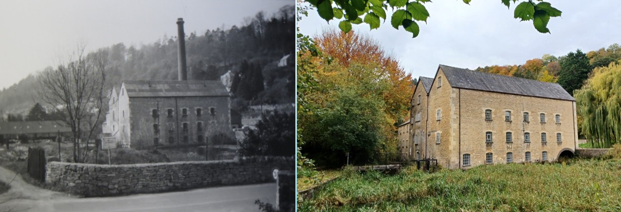
Please click on each picture to see it larger as the small versions really don’t do them justice.
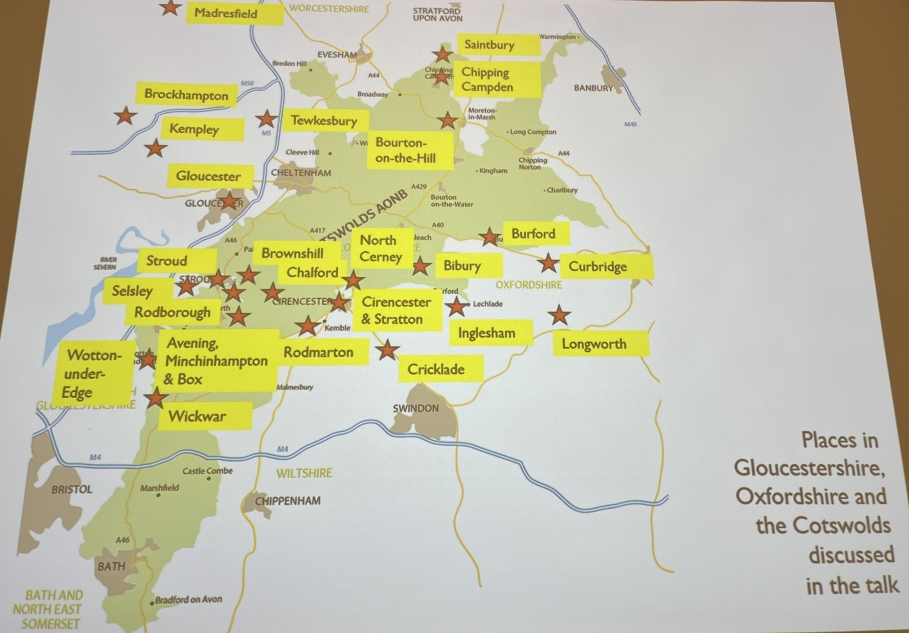
Wednesday 15 October – Arts & Crafts in Cotswold Churches – Kirsty Hartsiotis
A good turnout on an autumnal evening to hear local storyteller, writer and speaker Kirsty Hartsiotis talk about Arts & Crafts in Cotswold Churches. Kirsty began by distinguishing between those older churches with Arts & Crafts interiors or features and those churches entirely designed and built by craftsmen (and women!) from the Arts and Crafts Movement, which is generally considered to have started around the 1890s and continued into the 1920s, though its influence continued for some time afterwards. Kirsty then showed us a slide (reproduced below with her kind permission) of all the places she would be discussing in her talk, which she considered to have an Arts & Crafts heritage.
William Morris, probably the best known of the original founders of the movement is said to have visited Burford Church while it was undergoing restoration in 1877 and been horrified at the Vicar’s idea of “restoration”, which was less about conservation and more about rebuilding as he thought it should be done. This led Morris to form the Society for the Protection of Ancient Buildings, which ultimately led to the formation of the Arts and Crafts Movement itself in the 1890s. There were several interconnected families and groups of craftspeople in the early days of the movement. Kirsty described to us some of their complex personal and professional relationships – definitely one for further reading if you are interested to know more!
Jules & Jenny from Lincoln, UK, CC BY 2.0
Kirsty then explained that there is no such thing as a specific Arts & Crafts style. Rather it works on a set of principles encompassing both simplicity and splendour. Natural local materials were often used without being over embellished and nature motifs such as birds, animals and flowers were common. A fundamental principle was that the designer and craftsman worked together in harmony and this led to the formation of groups or workshops of craftsmen working together, for example Ernest Barnsley’s furniture makers at Pinbury Park near Sapperton, C.R. Ashbee’s Guild of Handicraft at Chipping Camden, and Peter Waals workshop first at Daneway and later in Chalford.
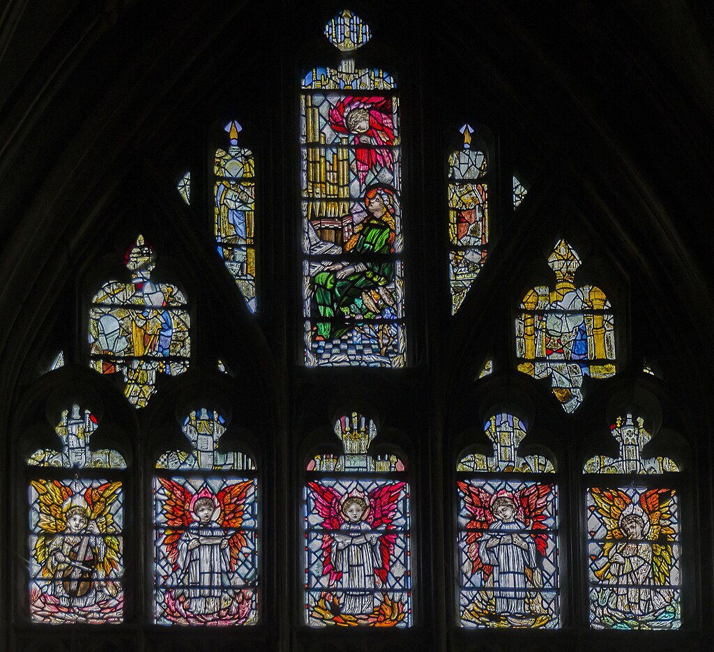
Kirsty also showed us many photos of the interiors of churches with Arts and Crafts features, especially stained glass which was a signature feature for many designers including Christopher Whall who designed the Lady Chapel windows at Gloucester Cathedral as well as many others. At Chalford we have a great example of collaboration between designers and craftsmen with the font, made by W. Simmonds but with the cover designed by Jewson and made in the Waals workshop.
Examples of full Arts and Crafts churches include Brockhampton in Herefordshire, unusual for its roof which outwardly appears thatched (in keeping with many local buildings) but inside is constructed from concrete, which made it fireproof and improved the thermal efficiency. It was commissioned by a wealthy local manor owner as many Arts & Crafts churches were and was designed by William Lethaby.

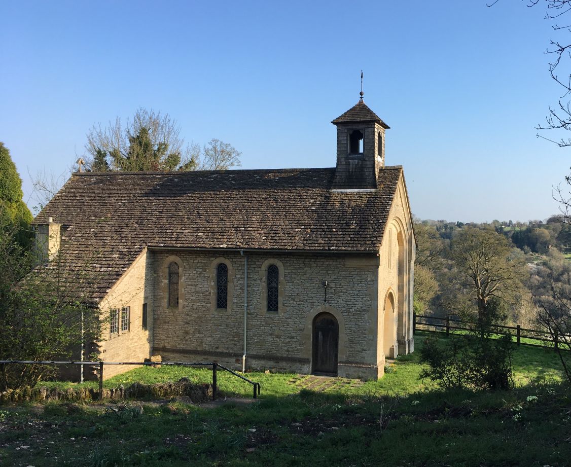
A second example (also commissioned by a wealthy landowner) is the church of St Edward the Confessor at Kempley in the Forest of Dean which was built in the early 1900s to a design by Randall Wells and includes the so-called “Jam tart” window. Some of the internal woodwork was made at the Waals workshop in English oak.
Some local war memorials were also designed and produced by Arts and Crafts groups. These include Painswick and Chipping Camden.
Other examples of local buildings either built by or substantially extended by Arts and Crafts designers and craftsmen include St Albans Church Stroud, Rodborough Little Chapel, Selsey Church (with stained glass windows by William Morris) and Rodmarton Chapel. Edward Payne also designed some of the stained glass at St John the Baptist, France Lynch.
Heather Collins
After World War I there was a change in style and a more “Gothic revival” style was favoured over the simplicity of the Arts and Crafts style. Some buildings still continued to be built though by those who preferred a simple style and locally we see this at the former Catholic Church of St Mary and the Angels at Brownshill, built in the 1930s and now (like many Arts & Crafts churches) looked after by a conservation organisation (Friends of Friendless Churches in this case).
Kirsty finished by saying that some of the Arts & Crafts tradition lives on today, especially in the production of modern stained glass, with the example of Tom Denny who has produced two new windows for Tewkesbury Abbey. In conclusion there is a lot of beautiful Arts and Crafts workmanship to see around the area and Kirsty’s map referred to at the beginning is an excellent way to start planning some days out to see it.
Annual General Meeting
A short AGM was held at the start of the October meeting. Chairman’s and Treasurer’s reports were presented.
Chairman Roger Carnt thanked the Committee for all their hard work during the year and as all had agreed to stand again they were re-elected en masse.
A proposal was made to alter the Group Constitution to allow for the suspension of membership fees for a trial period, to redefine “member” as someone who had received a programme card (given out on attending your first meeting this year) and to include wording relating to online banking in the finance section. There were no questions from the floor and the proposal was duly seconded and passed unanimously. You can find the Constitution here
Finally Heather Collins thanked Roger for all his hard work this year as Chairman.
Wednesday 17 September – Cider Making in Gloucestershire – Andy Meller
A good crowd on Wednesday 17 September to hear Andy Meller talk about cider making in Gloucestershire.
Cider making was brought to Britain by the Normans using a process based on olive oil pressing and the earliest English records of cider manufacture mainly centre around the monasteries, who had both the land, knowledge and time to produce cider. After the dissolution of the monasteries, many itinerant monks turned to farms to continue their craft, with farmers planting small orchards for the purpose. The impetus for this was that an agricultural worker could receive up to one third of his wages in cider, amounting to some six pints a day (or more in summer apparently!), with the result that much of the workforce was said to be drunk for much of the time. Workers would turn up with their own small barrel (Andy showed us an example of this) to collect their ration. This cider would have been a cloudy and not particularly appetising-looking drink of scrumpy that was very much restricted to the labouring poor.
Cider went upmarket in the 1600s, after a series of harsh winters in Europe affected the grape harvest forcing up the price of wine and this was given a further push in 1651 under the Puritans when the import of wine was banned. Two men led the drive to produce a more refined type of cider, Lord Scudamore who introduced new apple varieties including the Redstreak still widely used today, and Sir Kenelm Digby who after some experimentation managed to produce a thick green glass bottle much more robust than existing containers. His works at Newnham on Severn became a centre for glass making and some beautiful cider ‘flutes’ were produced at this time, examples of which can be seen in the Museum of Cider (see below). Fermenting the cider twice and fortifying it with brandy produced a clearer, sparkling pomagne that became popular with the upper classes.
In the 1700s, the Government, desperate to reduce the National Debt after the Seven Years War, introduced a cider tax, which gave the excisemen or ‘gaugers’ as they were known, the right of entry to any premises where they suspected cider was being made, including private houses. The lists for Gloucester City alone had 6298 cider makers named. The tax led to riots and major civil unrest, since it was seen as a challenge to the principle of the Englishman’s home being his castle. The row over the tax led to the Prime Minister stepping down and it was abandoned after only a few years.
The 1800s saw the formation of the well-known larger cider manufacturers such as Westons, Bulmers and Thatchers and the corresponding growth of Cider Houses, pub-style establishments selling only cider. Cider continued to be a popular country drink until the 1980s brought an influx of cheaper wines from the continent and saw a dip in demand. The advent of genuinely local craft ciders such as Severn Cider and Dunkertons in the last 20 years has seen a revival and we now have 19 cider makers in the county compared to only 8 in the 1950s. Stroud Farmers’ Market is an excellent place to buy local brands to try.
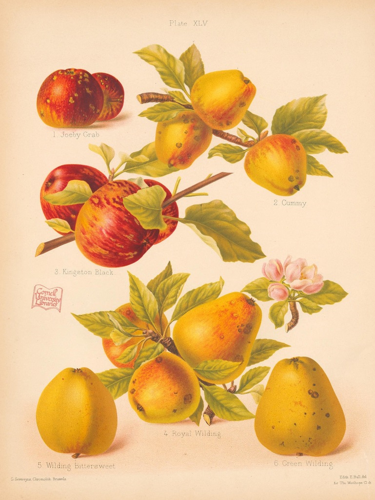
Cider apples are often very local, with each area having its own favourites and some wonderful old names still surviving. There are over 1000 varieties of cider apple, with Gloucestershire alone having over 100 that are native to the county. Cider apples are generally divided by the Long Ashton Classification into bittersweets and bittersharps, with most modern cider coming from the former. Within Gloucestershire we have lost about 70% of our cider orchards in the last 75 years, but there is a planting revival now taking place, spearheaded by the Gloucestershire Orchard Trust. Apple Day is on the 21 October 2025 so look out for local events.
So how do you make cider from the apple? As Andy commented ‘It’s easy to make cider, but it’s hard to make a good cider!’ Apples were shaken from the trees using a long hooked stick known as a panking pole. They were gathered into heaps (known as tumps), covered with straw and left to go soft for 2-3 weeks. Once soft enough they were milled or crushed to produce a brown mush known as the ‘cheese’.
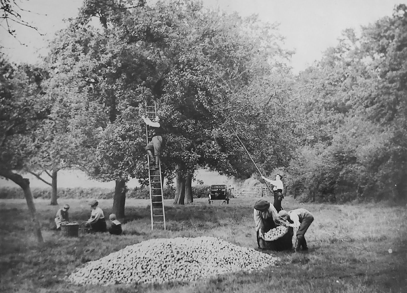
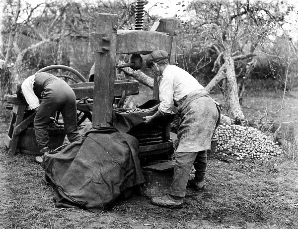
The original form of cider mill had two large stones and was usually powered by a horse pulling the top stone round so crushed fruit fell into the containers below. A more portable version from the late 1780s used a spiked drum known as a scratter with a hopper on top into which the apples were poured. This could be hand-powered and led to the development of travelling cider makers who went from farm to farm.
The cheese was then pressed to extract the juice, originally using single screw presses made from oak, but later with double screw metal presses. The resulting solids (known as pomace) were not wasted but fed to animals leading to many entertaining stories of drunken pigs and chickens staggering round the farmyard. The extracted juice was then decanted into oak barrels (traditionally brandy barrels) and left to ferment, relying on the wild yeasts already present in the juice, although many cider makers swore by adding some rather unsavoury ingredients including pieces of meat or (allegedly) even dead rats to encourage the fermentation. The call of the first cuckoo was said to be the traditional sign to open the barrels. For a more refined cider a second fermentation could be started and the cider cleared using various methods – one of which was apparently a bag of pig’s blood!
Finally, Andy regaled us with some traditional cider customs including the tradition of the Waas Hael (Wassail) or ‘health to you’, in which the villagers would exhort the trees to wake up and be fruitful in the year ahead. This may have included a torchlit procession, the drinking of toasts, the pouring of cider onto the ground, singing and the firing of shotguns or banging of pots to drive away the bad spirits. Each village had its own tradition for this and in some areas locally the Wassail has been revived in recent years. Gloucestershire is unique in having its own Wassail song, known to date back to 1790 and probably much further. Andy sang the chorus for us and if you want to hear the whole thing (well worth it!) see the link below.
Altogether a thoroughly entertaining evening which has hopefully encouraged a few of us to seek out our local artisan ciders and give them a go.
References and further reading
Gloucestershire Orchards Trust https://glosorchards.org/
The Museum of Cider (former Bulmer’s site) https://www.cidermuseum.co.uk/
Westons Cider Mill Tours https://www.westons-cider.co.uk/visit
A Gloucestershire Waes Hael (Wassail) (YouTube link so you may have to skip adverts first!) Gloucestershire Wassail | The Longest Johns
Wednesday 16 July – Guided Walk of Old Bussage
A small group of members spent a pleasant summer evening on a short, guided walk around Old Bussage led by Heather Collins with assistance from Peter Drover – even the sprinkling of rain was almost welcome after the 30 degree temperatures we’d had a few days before!
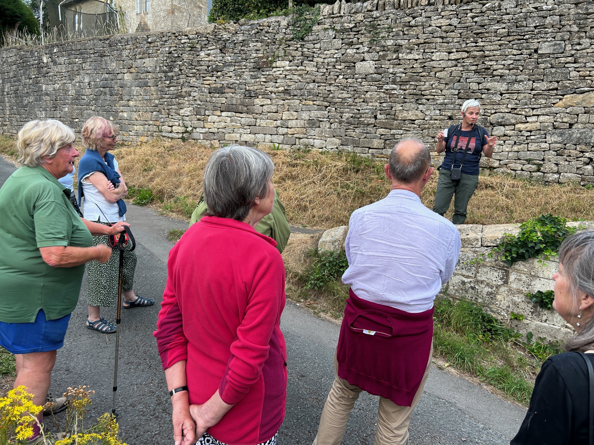
Starting at the Recreation Ground, the walk proceeded down Cowswell Lane, round a few of the back lanes, down Bussage Hill to the Church, back up towards The Ram Inn, along The Ridge to the Village Hall and returned to the Recreation Ground via a corner of Frith Wood.
Along the way we heard about the origins of both the village (as a squatter settlement) and its name and how it grew up around a couple of groups of cottages near to springs. The pattern of lanes has changed little since the 1840s and most people on the walk had never been down some of them before. We also heard about the history of some of the village’s more notable buildings – Bussage House, St Michael’s Church, the Old School and the Ram Inn, as well as other cottages that were formerly shops or original two up two down “squatter cottages”. There was a chance to see inside the church, and we are very grateful to the Revd Sue Murray for giving up her time to come and open it for us and explain a little about it. Most people on the walk had never been inside the church before so this was a great opportunity to see it.
Topics discussed on the walk included lime production in kilns in the quarry where The Chestnuts is now, the single war grave in the churchyard, the course of the old road through Bussage House grounds (the gateway still visible), enclosure of the Bisley Common, Beavis Coaches, and of course the School septic tank (one member’s family had previously owned the field it was in and Heather had other more pungent memories!).
We hope those attending enjoyed the walk, especially those who were able to share their own memories of Old Bussage and we look forward to doing a similar exploration of Bisley next year.
Wednesday 18 June – Stand & Deliver: Gloucestershire Highwaymen – John Putley
John began by asking the question “What exactly was a highwayman?”. Essentially they were simply thieves riding a horse who robbed travellers on the roads and they have been heavily over-romanticised by myth and legend in succeeding years as we shall see below!
The true highwayman does not appear until the 1700s, partly because there was far more travel taking place by this stage, but also because of the invention of the flintlock pistol. John had brought some replicas with him and gave us a quick demonstration of the loading and firing of the weapon. The flintlock was reasonably accurate at short range, fairly easy to acquire and small and light enough to hold in one hand to threaten travellers while taking their valuables with the other.
Contrary to popular legend, highwaymen rarely held up stagecoaches as it was too easy for an armed passenger to shoot back. Most robbed lone travellers or Post Boys targeting mainly money or tobacco which they could easily dispose of. After 1784 mail was more likely to be taken by the Mail Coach and these were not a good target for highwaymen as they had guards with blunderbuss weapons (John also had an example of one of these to show us!) and they travelled fast, stopping only to deliver the mail.
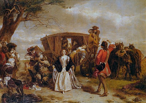
A wonderful example of romanticised highway robbery is shown in the picture on the left painted by William Frith, which purports to show the highwayman Claude Duval (A Frenchman working for exiled Royalists) holding up a coach. When the lady travelling in the coach agreed to dance with him, Duval allegedly returned part of the loot to her husband. He is supposed to have always acted with chivalry and abhorred violence and undoubtedly this contributed to the romantic notion we have today of highwaymen.
Many highwaymen had accomplices, such as publicans or doxies who passed on information about likely targets. Highwaymen were often former soldiers (especially ex-Royalist officers after the Civil War), disgruntled servants, young wealthy men who had got into debt or bankrupt tradesmen. Contrary to the popular image most did not wear masks but probably wore a neck scarf and pulled it over their face during the robbery. Few had their own horse as it was too expensive, and a horse might also help to identify the individual due to distinctive colouring. Instead, they might hire or steal a horse for a particular job.
Some women also took up highway robbery, mainly dressed as men and sometimes working alongside their husbands. The most notorious of these was Katherine Ferrers who according to popular legend was “The Wicked Lady” a highway robber who terrorised an area of Hertfordshire in the 1650s after the Civil War. Despite the 1945 film of the same name there is no real evidence for many of the daring exploits assigned to Katherine!
Mapping the “hot spots” for the activity of highwaymen, shows, unsurprisingly that they spread out from the larger cities such as London and Bristol along the main roads like the (modern) A40 and A46. Over 90% were operating in and around London, but of course there are numerous local examples too and John now turned to some of these stories. The Gloucester Journal is a great source for articles about local highwaymen and a favourite local spot for hold-ups was the top of Birdlip Hill near The George Inn.
The Dunston brothers, Tom, Dick and Harry operated from Fulbrook near Burford. They started out robbing local farmers on the way to market and then moved on to robbing travellers on the Gloucester Road. Finally, they turned to housebreaking, at which point Dick was seriously injured and presumed to have died during a robbery and his brothers were captured and hanged.
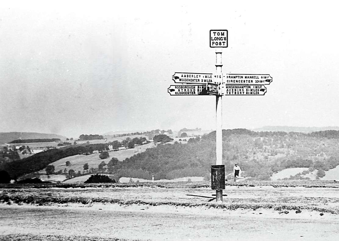
Our most famous local example is that of Tom Long, who local legend says was a highwayman from Minchinhampton, executed and buried on the common at the point where the famous signpost stands today, which is also considered as the site of a gallows or a gibbet. This is almost certainly an example of a completely fabricated story, and it is more likely that the site is either the burial spot for a suicide or maybe even simply a meeting point for travellers.
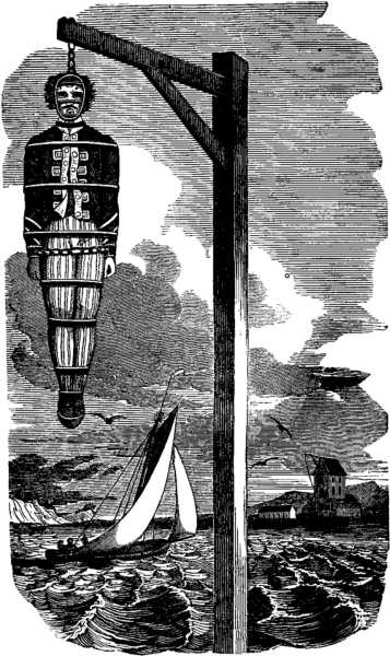
Daniel Neale, another local highwayman was seized at Chalford blacksmiths in 1763 when he was recognised by locals. Taken to The George at Bisley he tried to cut his own throat to avoid pubic execution but failed and was subsequently tried and then hanged at Gloucester. Thousands of people are said to have turned up for his execution and his body was hung on a gibbet after his death – a common fate for thieves of all types.
(Wiki Commons)
From 1800, the crime of “highway robbery” was formally introduced, making the whole thing a bit less romantic. Other factors which led to the decline of highway robbery activity were the increasing number of fences and gates (due to enclosure) making a swift getaway harder, faster coaches, busier roads, the potential for Inns known to support highwaymen to be closed down and finally less cash being carried or posted as more people were acquiring bank accounts.
Despite the gradual fading away of highwaymen, legends of their ghosts persist in many Inns and along roads where they plied their trade. Local examples include The Duke, a highwayman shot near the Puesdown Inn at Northleach, Tom Long who is said to haunt the Amberley Inn and Bill Clavers a former landlord turned highwayman at the Ragged Cot.
Highwaymen also live on in stories, poetry and song, although most of what we think we know about them from this is likely to be made-up. Dick Turpin for example, never did carry out his famous night ride to York!
Wednesday 21 May – Fore & Aft, the Story of the Purton Hulks – Paul Barnett
A good turnout to hear Paul Barnett speak about the formation, evolution and ongoing destruction of the ships’ graveyard at Purton on the River Severn, which is the largest site of its type in the country. Paul started by explaining the original purpose behind the idea of beaching ships on the river bank along the one and a half miles between the village of Purton and the entrance to the canal at Sharpness. In 1909 a riverbank collapse in the tidal Severn put the nearby canal at risk, as the canal at this point runs very close to the river. The idea was conceived to deliberately beach old wooden vessels here, let them fill with water and silt and allow them to form an erosion barrier. Boats were sunk at high tide, being “dropped” at full speed by a tug so that they ran onto the bank, then winched up further and holed to ensure they sank.
(Friends of Purton)
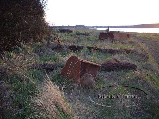
Boats of all types and from all over the country were beached here, with the last official beaching in 1965. Paul recalled playing in the hulks, many of which were still substantially complete, as a boy in the mid-1970s. After a career at sea, Paul returned to the area in 1999 and was horrified at the state in which he found many of the vessels. Some had almost entirely vanished over the years, either due to the wind and weather (silt accumulates at up to 15 cm per year on the river), but also unfortunately due to the actions of people. Some wooden boats had been burned (often to recover valuable scrap metal), some had been plundered for timber, and almost all had lost their nameplates and other distinguishing marks to souvenir hunters. There were no records as there is no legal requirement to document the “death” of a vessel.
Since 1999, Paul has been attempting to trace the history of the vessels and to get photos showing as many of them as possible in their working regalia. To date he has traced the history of 77 of the 80 ships beached at Purton. One interesting source for identifying the positions of the ships (many of which have virtually vanished at ground level now) was a series of photos taken in 1939 by the German Luftwaffe as part of their aerial reconnaissance! He was also given a collection of many thousands of photo negatives showing the working boats.
(Friends of Purton)
Paul went on to talk about the many different types of vessels that were beached here, accompanying each with photos showing them in their working days, after beaching but while still visible and relatively whole, and as they are now, often with almost no visible trace remaining as the boats have been buried beneath the surface.
Space does not permit discussion of all the vessels Paul mentioned, but a few of the more interesting ones included
- The working barge Newark, beached in the 1940s, mostly plundered for firewood and for building sheds locally and now almost totally vanished
- Ferrous Concrete Barges (most referred to only by numbers) built during WW2 as cheap lighters, beached in the 1960s
- Katherine Ellen a two-mast schooner with Irish connections, now entirely vanished but shown by magnetic survey readings to be largely still in situ underground.
- The only surviving Kennett barge, Harriett, beached in the 60s and now a scheduled ancient monument, included on the National Register of Historic Vessels.
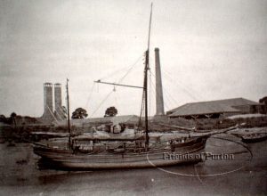
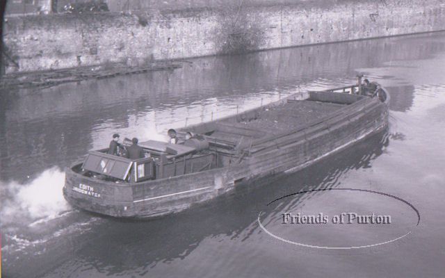
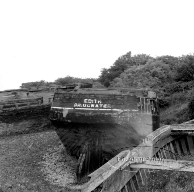
- Several Severn Trows, a vessel unique to the River Severn, including Edith, built in Chepstow and beached in the 1960s. Burned to the ground in the 1980s as an act of arson, a more recent survey has shown that there is still significant structure left underground. Photos of Edith throughout her life have been used to illustrate this article.
-

Edith shortly after beaching in 1965
(Friends of Purton)Several Stroud Trows. This was a vessel that could be operated from either end by shifting the rudder and tiller assembly, to get around the issue that it was hard to turn a large barge on the Stroudwater Canal as it was not wide enough in most places!
- Arkendale H and Wastdale H, the two steel barges involved in the notorious Severn Rail Bridge Disaster in 1960, in which five people died after the two vessels collided with the railway bridge.
(Friends of Purton)
Most of these vessels have no protection whatsoever and over the years have been damaged by treasure hunters, scrap metal hunters, arsonists, and day trippers. As described above, the barge Harriett was given protection as a scheduled monument in 2010 after extensive archaeological excavations in 2009, and some of the ferrous concrete barges also have protection. Paul continues to work today on the history of the site, telling the story of these forgotten vessels and raising awareness. The site is well worth a visit to see what is left and to view the information plaques put up by the Friends of Purton for each boat.
For further information see:
Purton – Friends of Purton – all the photos used to illustrate this article are copied from this site by kind permission of the Friends of Purton and Paul Barnett and remain their copyright.
Harriett | National Historic Ships
Wednesday 16 April – The Origins of Parish Road Names
A packed house at our April meeting to hear six members of the CPLHG Committee present the findings of their recent research into the history behind the road names across Chalford Parish. Hilary Burgess, Roger Carnt, Jim Bocock, John Dawson, Camilla Boon and Pete Drover took it in turns to present different sections, each highlighting their own area of research.
We learned that while some road names may indeed go back to early times, e.g. Abnash from the original Bisley Manor tything of Avenis which became Abnesse (multiple spellings exist!), the census and electoral roles show us that until relatively recent times it was not the norm to use road names in addresses locally. The introduction of post codes, the building of multiple cul de sacs and mini estates, the construction of the Manor Farm Estate and the requirements of the emergency services to be able to locate places quickly, all led to a significant number of new road names being adopted from the 1970s onwards. The Parish Council minutes show how some of these were selected in the 1980s and 90s, including those for Manor Farm. They also show that great discussion was often held to determine exactly where a road started and finished.
Among those road names discussed were
- Dr Middleton’s Road, named after a Chalford GP from the 40s-60s who had an unfortunate reputation for drink driving, but was also well regarded in his profession locally
- Sturmyes Road (which once had two alternate spellings on signs at each end!), from John Sturmy, whose Farm (now Pontins) became “Sturmy’s Court”, the ruling Manor for the southern part of Bisley Parish after a disagreement with the local Bisley Manor Court in the 1600s.
- Keble Road for Thomas Keble, both Senior and Junior having served as Vicars of the Bisley Parish, although many might have preferred Pyddoke Road after France Lynch’s own first curate who put up much of the money for the Church.
- Coppice Hill, for the practice of coppicing the hazel, which was used to make frames for the “tenters” on which cloth was stretched
- The “unofficial” names Farmer Gardiner’s Lane and Butler’s Hill for roads on the edge of France Lynch named after former inhabitants.
- Burcombe Road and Burcombe Way, used (with some interesting spellings on old maps!) since at least the 1880s. Combe means valley and it can be clearly seen on relief maps, but where the full name came from isn’t known.
- Watery Lane – an obvious one as water flows down it pretty much 24/7
- Silver Street. We’d had numerous ideas for this one in the week before the talk – water on the road, the Latin word for wood “Silva”, a name that sounded nice in other local towns and Chalford just adopted it, or possibly the appearance of the “white” surface due to the limestone before the tarmac came. No idea which is right but it was fun to discuss!
- Accommodation Lane, clearly marked and described on the enclosure map as an “occupation road”, so likely to mean accommodation as in “living quarters” in this case.
- The Frith appears on the Corpus Christi map of 1603 as Ye Frithe. Frith means wood, so Frith Wood is a tautology!
- Beech Lane (Brownshill) is shown on the enclosure map with a beech tree clearly marked on the map (sadly the original is no longer there)
- Pudney Pie Lane has several naming theories such as for the pig doors that open into it (pigs being made into pies?) or possibly as a slang word for donkey droppings. A very plausible idea suggested from the audience on the evening was that the shop was at one end of the lane and the bakers at the other, so maybe the “pudding pies” were transported along the lane.
- Brantwood Road appears to have been named after Brantwood House (which was formerly called Alma Villa), which had been a doctor’s surgery and then (in the 1950s / 60s) a restaurant. It was probably named after Brantwood House in Cumbria where one of the former owners came from.
- Skiveralls is first found in the Bisley Court Rolls in the 1500s and the house of the same name dates from around mid-1600, however the origin of the name is a mystery.
- Randalls Green is named after the Randall family who owned a mill in the area in the early 1700s. The name may also have referred to the adjacent drying area.
- Rack Hill is named for the racks (tenters) that were constructed here to stretch out the cloth for drying.
- Toadsmoor (and its various spellings!) is said by Mary Rudd, a local historian writing in the 1930s to have originated from “Tods More”, where a Tod is a young fox and More / Moor simply means open ground. Toad could also refer to one of the common inhabitants of the valley’s stream edges. On one map it is spelled Frodmore, but this is probably an error.
- Commercial Road did indeed have a number of businesses sited on it including The Fleece Inn, the Post Office and Gardiner’s Stores, so this could be the origin of the name.
- St Mary’s was named after a chantry in Minchinhampton Parish
- Belvedere once had a classical style statue of Apollo (The Belvedere Apollo is a famous ancient sculpture) although it vanished during the development and its whereabouts are now unknown
The road names on the Manor Farm Estate can be split into four categories
- Generic “country sounding” names such as Bluebell, Cuckoo, Lark, Hilltop, Foxes, Old Common
- Those named after places. Tanglewood after the old house in Brownshill that was renamed Templewood in the 1920s and destroyed in a place crash in 1946. Sezincote and Hidcote after well known Manor Houses. Farmcote possibly after a hamlet in Winchcombe that was mentioned in the Domesday Book. Those named after a View that can be (sometimes only just!) seen from them – Lypiatt, Burleigh, Ferris Court. Stonecote is a mystery, although Cote means cottage so it could just be a traditional sounding name!
- People. John Dorington was the “Lord of the Manor” at Lypiatt who was largely responsible for enclosure of the Bisley Common (where the estate is built) in the 1860s. John Sibree ran a Boys boarding school at Bussage House in the late 1800s and into the early part of the 20th century. Dorothea Beale was the niece of the famous headmistress of Cheltenham Ladies college and ran a girls boarding school at Bussage House from 1912 until 1937. Lionel Padin and Stanley Gardiner who both served in WW2 and then returned to Chalford to live started the collection of photos and slides that led to the publication of their many local history photo books and which now form the basis of the collection passed on by Mike Mills to CPLHG, which we use at our slide shows. Munday Close is named after a former Parish Council Chairman and Heavens Way after Gerald Heaven a former Parish Council Clerk.
The newest road name in the Parish is Sycamore Grove in Chalford. The name for this was suggested by CPLHG as the houses were built on the old football pitch which used to be known as The Sycamores.
Altogether a fascinating evening with many questions still unanswered but lots of food for thought.
Wednesday 19 March – England’s Oldest Showman – Steve Blake
At our March meeting, Steve Blake recounted the story of John Bellamy (1808-1893) once described as “England’s oldest showman” as he was still “on the road” with his exhibition of model buildings in the 1890s, shortly before his death at age 85!
Steve explained that he first became aware of Bellamy and his work when one of his model buildings – of Pitville Pump Rooms in Cheltenham – along with a portrait of Bellamy and his unpublished manuscript memoirs comprising some 179 handwritten pages, were given to a local museum. Steve has transcribed the memoirs and they form the main source for his story of Bellamy, although as they end abruptly in 1873, he has also drawn on other contemporary sources for Bellamy’s later life.
Although they came originally from Westbury-on-Severn, John Bellamy’s family were living in Bidfield Farm at The Camp when he was born and the young Bellamy was baptised in Bisley. His early life was unremarkable with jobs as a farmer’s boy and then as a servant. It was while working as a servant for a family in Fulham that he was first introduced to the art of making models of buildings, which would change the course of his life. Returning to live with his grandmother in Gloucestershire in 1830 he set out with his brother to try to make money posing as travelling minstrels. By autumn it was too cold to continue travelling around and he started making models for the first time; initially from card, but eventually from cork and at first as commissions from wealthy patrons.
These models in their various forms were to provide his living for the rest of his long life. In 1831 he had the good fortune for his models to be seen by King William IV and subsequently made his models under royal patronage. Finding it difficult to get a suitable display space, he resorted to having his own wagons built and travelled around the countryside living in one of the wagons and moving from fair to fair. His Windsor Castle model covered over 90 square feet and had over 2000 hand made windows. In 1857, Queen Victoria and Prince Albert had a private showing of his travelling exhibition and this cemented his connection with Royalty.
At the height of his fame, Bellamy’s “Royal Model Gallery” travelled in nine wagons, initially drawn by 16 horses but adapted for rail travel in the 1860s. Together they formed an exhibition space of some 70 by 40 feet and it must have been an impressive sight indeed when all set up. Sadly most of his larger models do not survive today, as having been sold to a gallery in Liverpool in 1877 they are believed to have been destroyed in the Blitz during the Second World War. Some models remain in private owenrship with Bellamy’s descendants and the Pitville Pump Room model remains in the possession of the Cheltenham Art Gallery and Museum, though sadly it is no longer on public display.
This is just a very brief summary of the fascinating life of John Bellamy which Steve recounted for us and there are many more details and some pictures of the models in an article writen by Steve for the journal “Gloucestershire History” in 2008, which has been published online by the Gloucestershire Local History Assiciation and can be found here
Wednesday 19 February – Lilyhorn Roman Villa and Local Pre-history, Pete Moore
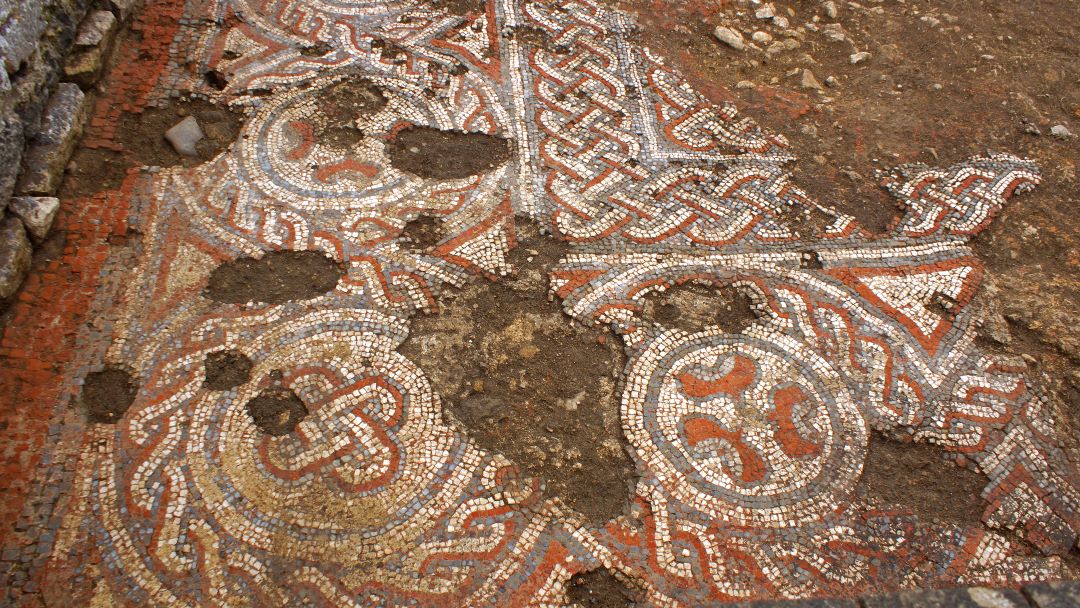
Another full house for us to learn about our unique local (but totally hidden) Roman Villa. Sited at the top of the hill above Bournes Green in ‘Church Piece’ field (wrongly indicated on O.S. maps incidentally), the site is protected by Historic England. Pete took us through the development of Roman villas in Britain, explaining that the Lilyhorn villa seems to have been the second largest in the Cotswolds (after Woodchester), and in the top 10 in GB, comprising over 25 rooms and numerous outbuildings.
Initially identified in 1700, the first (and only significant) excavation was conducted by Thomas Baker in 1841 and 1845. The site already largely decimated, over the years much of the stonework and mosaics have been scattered. Small finds include pottery fragments and metal fastenings (in Stroud Museum), a significant hoard of coins (what was not traded is in Corinium Museum), glass fragments, tiles, oyster shells, and.. skeletons (possibly of slaves).
Clearly a villa of some opulence there are questions as to why it was sited there. The situation overlooking the valley is certainly key, and its possible extensive sphere of influence over local farmland. It followed on from local prehistoric and Iron Age sites such as Money Tump and Bagendon. Pete’s comprehensive overview was fascinating, highlighting many of the answered and unanswered questions about the site.
Wednesday 15 January – Slide Show – Mike Mills and Beyond
A full house in the France Lynch Church Rooms to hear four members of the Committe present a selection of “slides” both from the Stan Gardiner / Lionel Padin / Mike Mills collection and from a series of more recent (1960s/70s/80s) negatives from the Stroud News and Journal (SNJ).
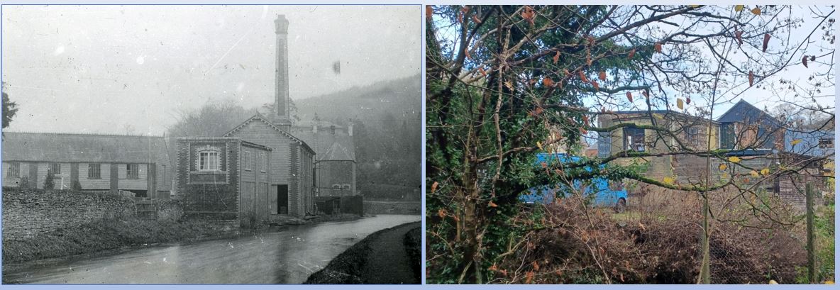
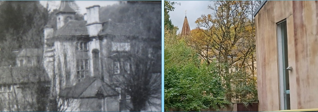
Peter Dover, started off the presentation with a selection entitled “Then and Now”. Using a selection of old photos from the Mike Mills collection, Pete had tracked down the locations and taken a modern photo as close as possible to the viewpoint of the original. The selection included street and canal towpath views, pubs, schools and a view of the Victoria Steam Joinery Works, where it proved challenging to get to the same viewpoint today. The picture left shows Victoria Works, with the archive picture on the left and Pete’s modern version on the right. The wooden shed in the old picture is long gone, but the building shapes remain the same.
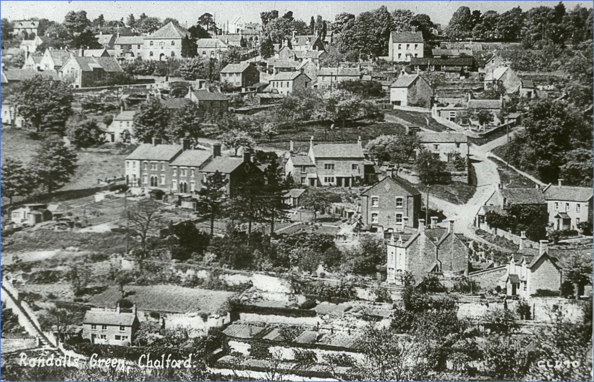
Roger Carnt then continued with a selection entitled “Old and Sporty”. This included several pictures from the SNJ archives of sports teams (some now in our new gallery see next section for details), a few of local “personalities” and some views in and around Chalford, including the one on the right which very clearly shows the area known as Randall’s Green.
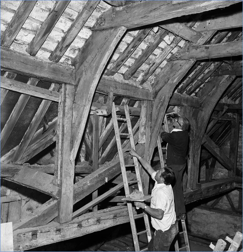
Camilla Boon followed with a section entitled “Mainly People”. Photos in this section were exclusively from the 1960s onwards and resulted in a great many comments as people in the audience recognised themselves or others. As a result of this response and hoping to capture some of the information, we’ve put a few of these photos on a new gallery page here and also on our Group Facebook page here (Private group so you need to join to view and participate) and we’d like to encourage you to look and comment if you think you might recognise anyone. Any information we receive will be recorded in our database along with the photo, so your contributions will be saved for posterity! The photo on the left shows the interior of the roof of the former Company’s Arms.
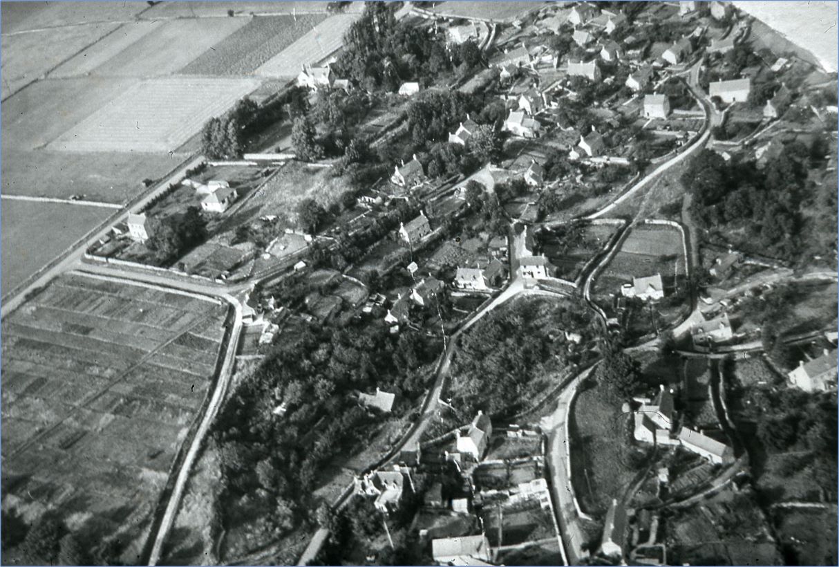
Heather Collins concluded the show with a section entited “Miscellaneous”. This had everything from 1970s school photos to older views in and around Chalford, and again one or two of these photos will be in our new gallery and on our Facebook Group page for people to comment on. The photo on the right is an aerial picture of France Lynch (note no Sports and Social Club!) and we’d love to be able to date it more accurately, so if anyone can see any feature missing from or present in the photo which gives more of a clue to the date please contact us here